- 2024-06-12 15:26 131594
- 产品价格:面议
- 发货地址:北京海淀 包装说明:不限
- 产品数量:9999.00 套产品规格:不限
- 信息编号:174306892公司编号:14832749
- 王经理 微信 185101038..
- 进入店铺 在线咨询 QQ咨询 在线询价
evs中文版使用教程 EVS Pro 诚信代理
- 相关产品:
科学软件网提供大量正版科学软件,满足各学科的科研要求。科学软件网专注软件销售服务已达19年,全国大部分高校和企事业单位都是我们的客户。同时,我们还提供本地化服务,助力中国的科研事业。
Inverted grids representing air or water bodies can also be created where the bottom surface is defined by an input surface (such as bathymetry) and the top of the grid is defined at a constant elevation or constant thickness.
Using EnterVol for ArcGIS as a true ArcGIS extension you can now:
Studio包含了DrillGuide技术,它运用综合地质统计学来提供定量评估现场评估的质量,并在需要额外调查的地点确定佳新取样地点。无论你是在寻找黄金或地下水污染,这个成熟的技术都可以较大地降低现场评估成本。我们的工具提高了现场评估的效率,提高了分析和数据评估,补救规划,诉讼支持,监管报告和公共关系的能力。
Environmental Visualization System (EVS Pro)是用于良好性分析,可视化和动画的早的产品。它包括高级网格模块,建模工具,输出选项,地质统计分析、 动画分析、GIS功能等。更多的功能还包括高级动画输出、实时地形漫游、高级地质结构建模、交互式分析、4DIM & VRML II 输出;ODBC数据库链接等。
EVS Pro的渲染提供了显著、完整的三维可视化技术以对污染的状况进行充分分析和可视化。
Earth Volumetric Studio (Studio) is the revolutionary synthesis of C Tech’s Environmental Visualization System and Mining Visualization System integrated with new technology from years of EnterVol development. Earth Volumetric Studio retains the modular toolkit paradigm of its predecessors in an updated, user friendly environment.
Earth Volumetric Studio is a standalone Windows program which offers the ultimate in speed, power and flexibility. Studio unites advanced volumetric gridding, *statistical analysis, and 4D visualization tools into a software system developed to address the needs of all Earth science disciplines. The graphical user interface is integrated with modular analysis and graphics routines which can be customized and combined to satisfy the analysis and visualization needs of any application. Studio can be used to analyze all types of analytical and *physical data in any environment (e.g. soil, groundwater, surface water, air, noise, resistivity, etc.). Earth Volumetric Studio’s integrated *statistics provides quantitative evaluation of the quality of your data and site models and identifies locations that require additional data collection.
体绘制
EVS Pro的体绘制提供了代表污染物羽流的另一种完全三维可视化技术。
科学软件网为全国大多数高校提供过产品或服务,专业销售和售后团队,确保您售后**!
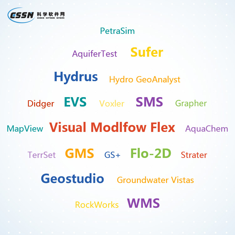
联系电话是4008104001, 主要经营北京天演融智软件有限公司(科学软件网)主营产品PSCAD, CYME, SPSSPRO, Stata, Matlab,GAMS,Hydrus,GMS,Visual Modflow 等各学科软件,科学软件网有20多年的软件销售经验,提供专业销售和培训服务,还有更多的增值服务。目前,科学软件网提供的软件有数百种,软件涵盖的领域包括,经管,仿真,地球地理,生物化学,工程科学,排版及网络管理等各个学科。。
单位注册资金单位注册资金人民币 1000 - 5000 万元。