

- 2025-04-14 15:26 5994
- 产品价格:面议
- 发货地址:北京海淀 包装说明:不限
- 产品数量:9999.00 套产品规格:不限
- 信息编号:241989505公司编号:14832749
- 王经理 微信 18510103847
- 进入店铺 在线留言 QQ咨询 在线询价
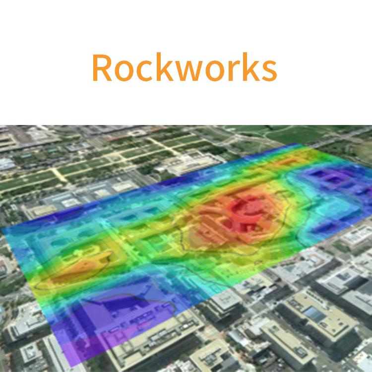
正规代理_rockworks2021_rockworks正版软件使用教程
- 相关产品:
北京天演融智软件有限公司(科学软件网)前身是北京世纪天演科技有限公司,成立于2001年,专注为国内高校、科研院所和以研发为主的企事业单位提供科研软件和服务的国家。
RockWorks2020 is offered with three different feature levels: Basic, Standard, and Advanced. Which is right for you?
All three levels include the RockWorks Datasheet and the ModOps, Utilities, and Graphics menus. These menus offer numerous programs for mapping XYZ data, modeling XYZG points, creating stereonets and rose diagrams, creating Piper, Stiff, and Durov plots, and much MUCH more. This is the general RockWorks “toolbox.”
Other Map and Diagram Features
Borehole Location Maps – Display maps symbols from the database, or used fixed symbols.
3D Cylinders – Specify the number of sides in 3D cylindrical entities (such as logs) for faster display and smaller export.
Display multiple surface profile polylines (such as ground surface AND water table) in cross sections.
Solid model reveal animations offer starting view, zoom, stretch, colors, and more. Include up to 12 different changes of direction.
Solid isosurface animations offer 6 cutoff levels for finer detail.
Automatically hide time-data striplogs with no data for the sampling date.
Processing speed has been improved by 30%
RockWorks为分析地表和地下数据提供多种选项,并接受不同的文件类型,如地层、岩性、井下地球化学/地球物理学/岩土测量、颜色间隔、裂缝和含水层数据等。内置的2D和3D查看/编辑窗口的RockWorks graphic output可导出图形,或导出到CAD、Google Earth和GIS程序中。使用ReportWorks模块可为报表和海报生成页面布局。
RockWorks提供以下三个版本供选择
Basic:所有实用程序,加钻孔管理地图,日志,日志部分。
Standard:包含Basic功能,还包含了井眼管理建模:岩性,地层,地球物理/地球化学/程,含水层,颜色,裂缝。
Advanced:包含Standard功能,还包含了SQL-server数据库支持、程序自动化(脚本)、3D断层、钻井管理石油生产图。
License Level Basic Standard Advanced
Utilities (including EarthApps) √ √ √
Logs & Sections √ √ √
Borehole-Based Modeling √ √
SQL Server, Automation, 3D Faulting √
应用领域
程
RockWorks提供程和土木的图形和分析工具,用于评估建筑和挖掘场地。创建钻孔记录和横截面,几十种不同类型的地图、结构图、地质/岩土/裂缝/颜色模型和体积报告等。不管您是在项目前期、中期或后期,RockWorks都可以为您和您的客户节省时间和金钱。
Use QuickMap for Borehole Locations:
The new QuickMap tab provides a quick look at all the boreholes in your project. Quickly “know your data” with a visual display of borehole spacing and distribution.
Sub-Sites:
Create sub-sites within larger projects for quick selection of boreholes and loading of sub-site dimensions.
Oil and Gas Production Data (RockWorks Advanced only):
A new Production table has been added to the RockWorks17 database for storing well production data by date and for generating a variety of graphs: Average Daily Oil Production, Cumulative Oil Production, Average Daily Gas BTU, etc.
Mapping Tools:
Add existing RockPlot2D files as “overlays” on new maps being generated.
Animations and Other Tools:
Easy-to-use Grid Morph program – add dates and go directly to video animation.
Redesigned PicShow program for easier animation and movies.
19年来,公司始终秉承、专注、专心的发展理念,厚积薄发,积累了大量的人才、技术以及行业经验,在行业内得到了大量用户的认可和高度价。


