

- 2024-07-01 15:26 3794
- 产品价格:面议
- 发货地址:北京海淀 包装说明:不限
- 产品数量:9999.00 套产品规格:不限
- 信息编号:251173262公司编号:14832749
- 王经理 微信 18510103847
- 进入店铺 在线留言 QQ咨询 在线询价
rockworks_rockworks2021
- 相关产品:
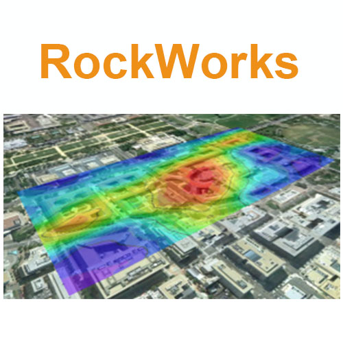
RockWorks
使用期限:*许可形式:单机原产地:美国介质:下载适用平台:windows
科学软件网销售软件达19年,有丰富的销售经验以及客户资源,提供的产品涵盖各个学科,包括经管,仿真,地球地理,生物化学,工程科学,排版及网络管理等。此外,我们还提供很多附加服务,如:现场培训、课程、解决方案、咨询服务等。Modeling Features
Time-Based Modeling – New T-Data Multiple Solids program automatically creates “snapshot” models at designated time intervals which can be constrained by a permeability model and output to a variety of animation programs. Refer to the TCE Site sample project and tutorial.

New Automatic Polygon Clipping – All gridding and solid modeling programs now include an option for clipping the model based on an automatically-defined convex polygon defined by the control points, analogous to stretching a rubber band around the boreholes.
Clip Grid Models using polygons in a table or a map.
New Spatial Filtering – All programs that involve coordinates now include a spatial filtering option so that subsets (including zones between surfaces) can be selectively analyzed/modeled.
New Time-based filtering options have been added to the Hydrochemical utilities (i.e. Durov Diagrams, Piper Diagrams, Stiff Diagrams and Stiff Maps) as well as any programs that might include striplogs (in order to filter water levels and/or T-Data).
Create a depth to target grid model for specified values in a solid model.
Calculate where two grids intersect, such as a water table and surface topography.
Import 5 meter DEMs to a RockWorks grid model.
Create a solid model in which the voxel values between two surface model grids are defined by another grid (e.g. ore grades).

Solid model reveal animations offer starting view, zoom, stretch, colors, and more. Include up to 12 different changes of direction.
Solid isosurface animations offer 6 cutoff levels for finer detail.
Automatically hide time-data striplogs with no data for the sampling date.
Processing speed has been improved by 30%

RockWorks is the standard in the petroleum, environmental, geotechnical and mining industries for surface and subsurface data visualization, with popular tools such as maps, logs, cross sections, fence diagrams, solid models and volume calculations.
科学软件网不定期举办各类公益培训和讲座,让您有更多机会免费学习和熟悉软件。


